

Scope
The EPA WaterSense Home Specification does not have mandatory outdoor requirements. However, if installed, these systems may contribute to the mandatory 30% efficiency requirement. Refer to the specific WaterSense Approved Certification Method (WACM) for specific requirements.
The following are recommendations and best practices:
If the house site is sloped and/or is located on a waterway or shoreline, especially in climates prone to heavy rains and rainstorm events, take steps to mitigate current or potential future erosion.
- Use short-term erosion control methods to stabilize soil on sites during construction.
- Plant vegetation on any ground that slopes greater than 25%. For any slopes greater than 50% (1 foot vertical rise for every 2 feet horizontal run) install plants that do not require mowing.
- Consider terracing or retaining walls for steep slopes.
- To control erosion of steep riverbanks, consider alternatives to riprap, including ground stabilization techniques such as bio-engineering, hydro-seeding, controlled planting, the construction of engineered logjams, and the use of erosion control products. Levees may be necessary to prevent flooding of low lands containing important pre-existing infrastructure or buildings.
- For shoreline development, follow local ordinances regarding dune and shoreline preservation.
See the Compliance Tab for links to related codes and standards and voluntary federal energy-efficiency program requirements.
Description
Erosion from rainstorms, flooding, and wind can ruin landscaping, disrupt local sewer systems and stormwater management, and even destabilize a site threatening the stability of homes and other structures.
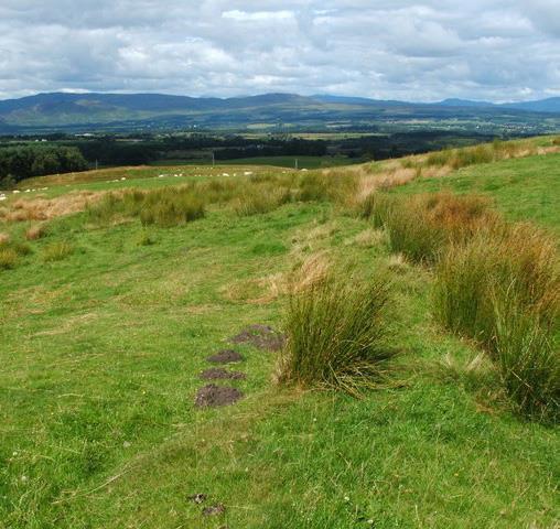
Builders should plan for and employ short-term erosion practices during construction and long-term erosion practices for the long-term protection and safety of the home, especially at sloped sites in areas prone to heavy rains, which may be subject to erosion, displacement of topsoil, and mudslides, and at sites located on or near waterways which may be subject to storm-related flooding. There are several erosion-resistance measures builders can employ. Discussed here are practices to employ during construction including the use of mulch and erosion control products and long-term measures including vegetated slopes (Figure 1), terracing, riprap and bio alternatives, retaining walls, and barriers, and special concerns for coastal construction. When siting a home, designers should take into account the long-term risks to the location including erosion and mudslide risks for homes located on slopes.
Source
Erosion Control on Construction Sites
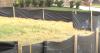
Erosion control is often needed on site during construction when vegetation on site is disturbed leaving soil exposed to wind and rain. Erosion control measures should be part of construction site planning. Some builders will grind up wood scrips to use as mulch around newly constructed homes to stabilize soil until landscaping is planted. Straw, bark dust, shredded paper, and leaves can also be used as mulch. Straw bales, sandbags, and silt fences can be used temporarily for slope stabilization and to keep sediment out of drainage inlets. Erosion control products like blankets and bags can be used in conjunction with mulch to stabilize sloped ground and disturbed soils and as ground preparation for planting (NRCS).
Builders should follow the erosion and sediment control requirements of their local municipality. Example steps may include the following: (Santa Cruz 2008, Jackson Township 2014)
- Limit vegetation removal to the extent possible. Mark off trees to be kept with plastic fencing.
- Revegetate the site as quickly as possible. Seed bare soils with a temporary cover of a grass seed like annual ryegrass or barley. This can be covered with 2 to 4 inches of straw.
- Place erosion control blankets on slopes.
- Employ sediment control including straw rolls, gravel bags, and/or silt fence at the base of slopes. Leave a vegetated strip at site perimeter if possible.
- Protect storm sewer inlets and drains from sediment by surrounding with gravel or stone-filled geotextile bags.
- Create a temporary roadbed of gravel or rock at the entrance to your site to keep vehicles off bare soil.
- Remove and stockpile topsoil upper 4 to 6 inches of site surface. Locate stockpile away from downslope street, driveway, stream or drainageway. Seed the stockpile with annual ryegrass or winter wheat and/or place sediment barriers around it. Remove subsoil as needed from site and stockpile in a separate pile.
- Periodically check and maintain stormwater and sediment control practices throughout construction.
- After house is completed as soon as gutters and downspouts are installed, add extenders to downspouts to direct water past bare soil. Direct drainage away from bare soils and fill areas. Disperse drainage flow over vegetated areas and place rocks at the base of drainage outlets to dissipate the energy of the flowing water and prevent scouring of the ground beneath the diversion pipe.
- As soon as all outside construction is complete, redistribute top soil and revegetate the lot with sod, seed, and mulch. Spread straw mulch on newly seeded areas, using 2 to 3 bales of straw per 1,000 square feet.
- On flat or gently sloping land, anchor the mulch by crimping it 2 to 4 inches into the soil.
- On steep slopes, anchor the mulch with netting or tackifiers. Or, use erosion control blankets.
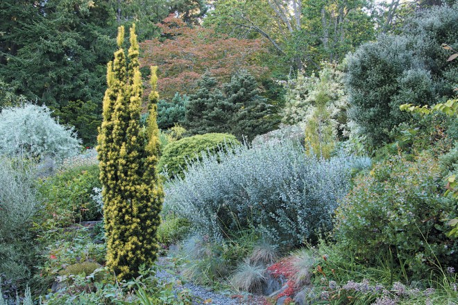
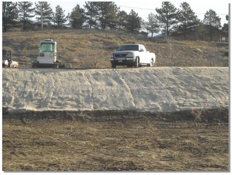
Erosion control products include woven mats to lay over loose soil or rolls of woven material-filled mulch to hold soil in place (Figure 2). The blankets or woven bags can be made of natural biodegradable fibers like jute or coconut fiber or synthetic material and are laid over disturbed ground, on steep slopes, in areas with highly erosive soils, or to stabilize drainage ways (Figure 3). These products can be used to control erosion in conjunction with revegetation efforts, providing seedbed protection from wind and water erosion (MHFD 2010).
Source
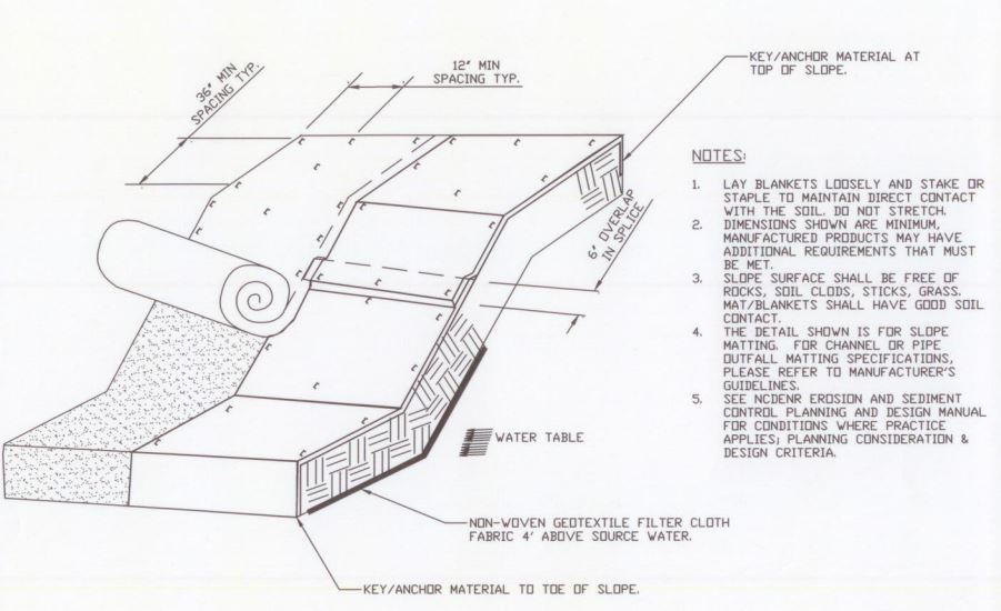
Guidance documents describing Erosion Control Blankets (ECBs) use as a construction material that provides temporary cover and support for establishing vegetation on bare soil. ECB holds topsoil and seed (typically grass) in place to minimize erosion during germination of seed.
Source
Temporary biodegradable rolled erosion control products are listed below along with the maximum gradient for which they are recommended:
- Mulch control netting, max. 5:1
- Open weave textile, max. 1.5:1
- Single-net Erosion control blanket, max. 3:1.
- Double-net Erosion control blanket, max. 2:1.
- Slowly degrading Erosion control blanket, max. 1.5:1.
- Netless erosion control blanket, max. 4:1.
Another product is turf reinforcement mat, a permanent, non-degradable product composed of synthetic fibers, filaments, nets, wire mesh, and/or other elements, processed into a thick permanent mat to provide long-term erosion protection in high-water-flow conditions.
For more on mulching and landscaping, see the Solution Center guides Mulching and Water-Efficient Landscape Design.
Vegetated Slopes
Steep slopes in landscapes present a challenge for the landscape design because of the potential for erosion and runoff from stormwater and irrigation water. Streams that run through the site, and rivers or shorelines running along the site also present the likelihood of erosion along banks and shorelines and the potential of seasonal or occasional flooding. Several erosion-mitigation practices are described in this guide. For additional site water control techniques see the Solution Center guide Swales, Drains, and Site Grading for Stormwater Control.
Care should be taken to ensure that appropriate plantings are used and that only irrigation methods suitable for slopes are applied. South-facing slopes can warm up and dry out more quickly than other areas, while north-facing slopes can be cooler than surrounding areas.
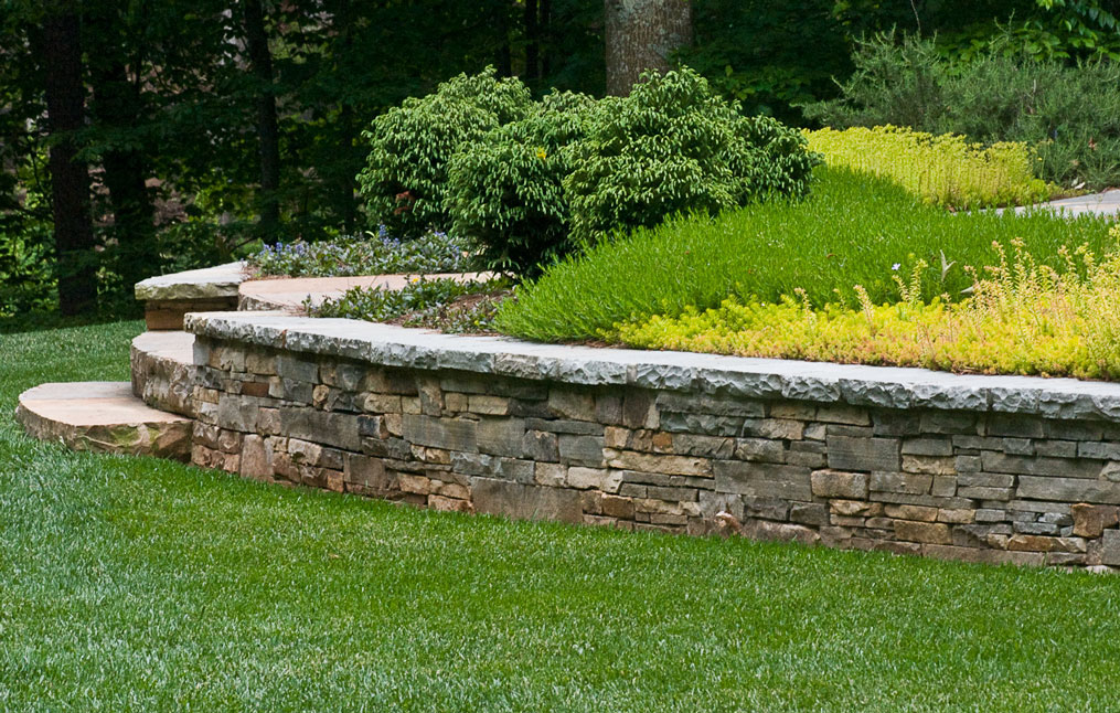
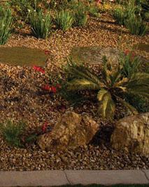
Considerations must be given to the plantings installed on slopes, as it may not be safe to operate a lawn mower on slopes greater than 2:1 (2 feet of horizontal run per 1 foot vertical rise). Trees and shrubs create a tight network of roots and stems that not only bind soil particles together but also act to slow the force of water flowing down hillsides (Figure 1). Turf grass on steep slopes can help to bind the soil with roots but might not slow down stormwater runoff. Thus, heavy rains can wash away turf, roots and all. Taller growing grasses, wildflowers, shrubs, and trees do a much better job of slowing stormwater runoff from steep slopes.
Terracing
Terracing is an alternative approach to planting on slopes (Figure 4). Open terraces can be dug into the slope in the shapes of steps. The existing slope can be cut, and the excavated soil can be used as fill. A low soil berm (ridge) can be formed at the front edge of each step or terrace to slow the flow of water.
In areas that experience heavy rains or intense rainstorm events, and in locations near the coast or inland waterways, erosion can be a serious problem, especially on sloped ground. The following sections address erosion control measures that will work on steep ground, near inland waterways, and in coastal environments.
Source
Rivers and Streambanks - Riprap and Recommended Alternatives
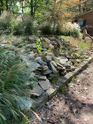
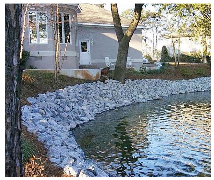
Riprap, also known as rock armor, is the layering of angular rocks along a steep slope, river bank, or tidal shoreline to counteract the constant wearing brought about by heavy rains, high tides, or flooding events. While riprap can be an effective measure against erosion on steep slopes (Figure 5), its use for stream banks, especially right at the water line (Figure 6), can have unintended consequences (FEMA 2009). While natural shorelines consisting of riparian zones of vegetation and log debris provide a rough shoreline that slows water flow and provides shade and fish habitat, riprap-lined shores provide a harder surface that increases water velocity, which can lead to erosion further downstream. The faster flow and smoother shoreline also provide less habitat and hiding places for fish, and sunlight reflecting off the rocks can increase water temperature to unhealthy levels for fish. It is also not a permanent solution as the soil beneath the rocks is still subject to erosion (FEMA 2009). In its report, Engineering with Nature: Alternative Techniques to Riprap Bank Stabilization, FEMA recommends and describes several alternative ground stabilization techniques including bio-engineering, hydro-seeding, controlled planting, and the construction of engineered logjams. Another option is the use of erosion control products.
Source
Source
Document explores alternatives to riprap on banks and waterways to mitigate bankside erosion in the Pacific Northwest.
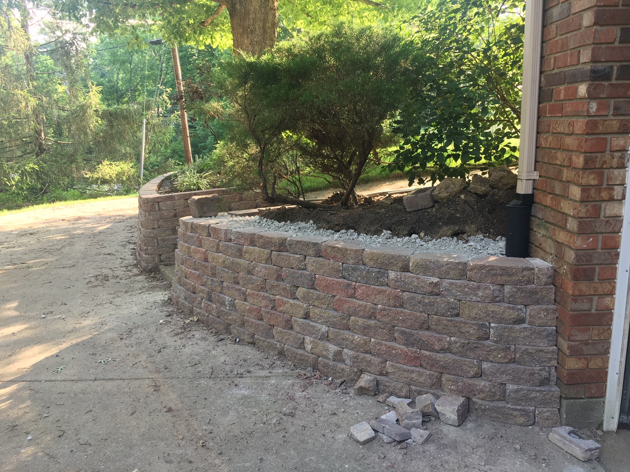
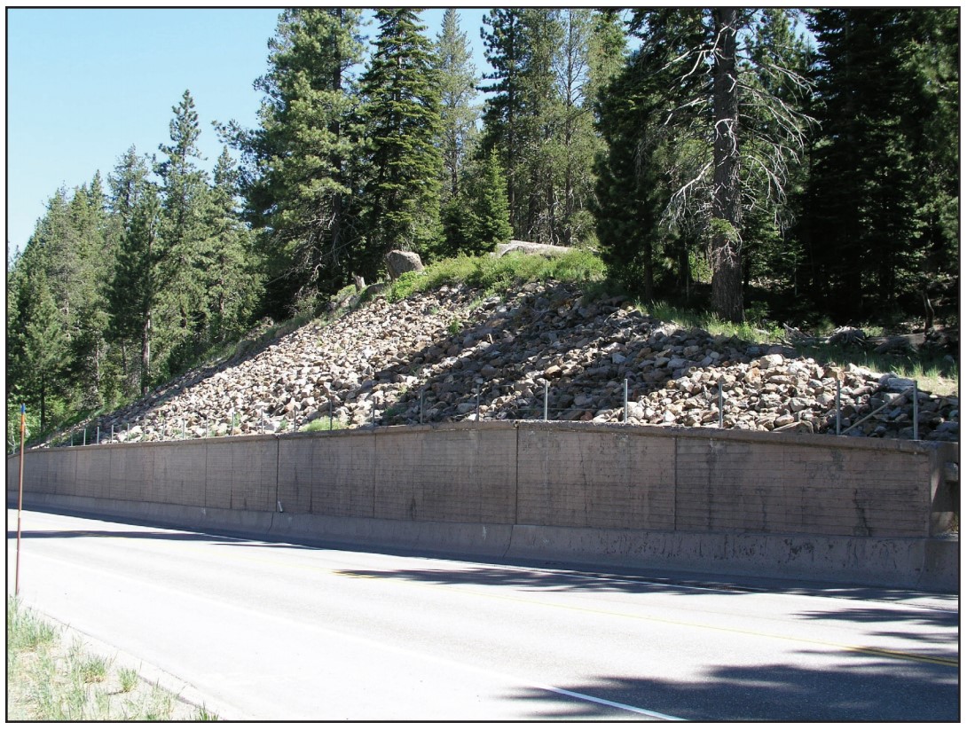
Retaining Walls
Retaining walls are permanent barriers that support hillsides on sites (Figure 7). They are designed to contain the weight of the terrain on a steep slope in situations where, without a retaining wall, heavy rain might destabilize the exposed terrain and cause a landslide. These structures are beneficial in areas where erosion is inevitable or where critical infrastructure needs to be protected (Enterprise Community Partners 2019). Retaining walls can be built of reinforced concrete, paver stones, mortared stone or concrete block, or brick. On the uphill side of the retaining wall, a drain pipe (sometimes referred to as a French drain) should be installed consisting of a perforated PVC pipe surrounded by gravel and filter fabric to keep dirt out of the pipe; the pipe collects and diverts water from the base of the wall to a lower portion of the site or to a drywell (Enterprise Community Partners 2019).
Source
Barrier Measures
Barriers, such as floodwalls and levees, can be built around a home or community to contain or control floodwaters. A levee is a manmade structure usually made of compacted soil, while a floodwall is a structure typically made of concrete or masonry measuring between 1 and 6 feet tall that are typically permanently installed around buildings (FEMA 2015).
Floodwalls can be built with gates or ramps or stairs for passage over the wall by vehicles or pedestrians. Sump pumps or an internal storage system along with a back-up emergency power supply are required to collect and remove floodwater that collects behind floodwalls during a flood event. The top of the floodwall should be above the base flood elevation (FEMA 2015).
Temporary wood deflector walls and plywood protective coverings can be used to protect sites from seasonal mudslides for example during spring snow-melt or in areas that get very heavy seasonal rains (NRCS). However, longer term solutions for slope stabilization should be employed.
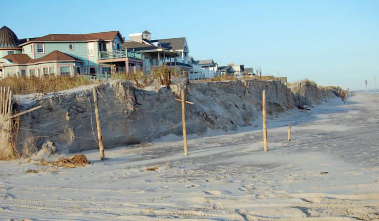
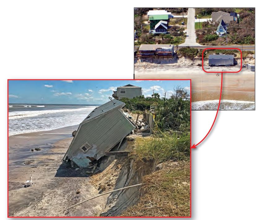
Coastal Construction and Dunes
Dunes provide a natural buffer against coastal hazards and provide sand for the replenishment of beaches (FEMA 2014). Coastal dunes are not static; they can change in size, shape, or location due to seasonal weather impacts and the impacts of storms and coastal wave events (see Figure 8) (Enterprise Community Partners 2019). A primary frontal dune (PFD) is defined by the National Flood Insurance Program (NFIP) as a continuous or nearly continuous mound or ridge of sand with relatively steep seaward and landward slopes immediately landward of and adjacent to the beach. Primary frontal dunes are subject to erosion and may be vulnerable to overtopping or breaching from high water levels and waves during coastal storms. The National Flood Insurance Program recognizes the importance of dunes in reducing coastal flood hazards and has established special mapping, insurance, and floodplain management criteria designed to help communities protect the dunes. As the first line of defense against flooding, primary frontal dunes are typically mapped as a VE Zone, a designation by the National Flood Insurance Program. This designation ensures that dunes are not subject to manmade alterations in a way that could increase potential flood damage (FEMA 2014). The recovery of dunes can be accelerated by replacing eroded dunes with compatible sand, planting native dune grasses, and installing sand fences (FEMA 2020).
Dune construction, repair, and reconstruction under or around elevated buildings may be assumed to be acceptable as long as the scale and location of the dune work is consistent with local beach-dune morphology and reasonable vertical clearance is maintained between the top of the dune and the elevated building’s floor system (FEMA 2014). ASCE 24-14 permits dune construction and reconstruction under and around elevated buildings but requires an engineering report documenting that the fill placement will not cause building damage by wave runup or reflection or deflection of floodwater (FEMA 2014).
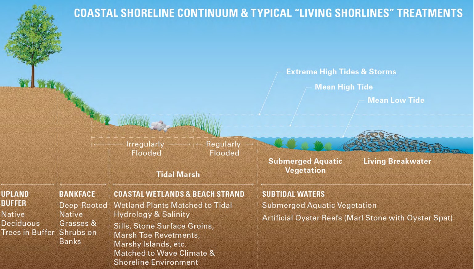
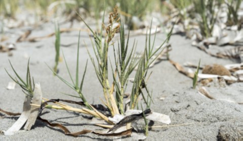
Planting native vegetation alongside conventional “hard” or “grey” solutions provides stability to the shoreline. Bioengineering solutions provide a self-stabilizing, low-maintenance solution for impaired shorelines and eroding bluffs (Figure 9) (FEMA 2018). In sandy dunes, seashore dropseed, salt hay, or strongbark are recommended (Figure 10) (Enterprise Community Partners 2019).
Source
Volume 1 of a two-volume report providing a comprehensive approach to planning, siting, and risk management for homes constructed in coastal environments.
Source
Document discussing methods to bioengineer stabilization of shorelines using living and non-living plant materials in combination, known as the “Living Shorelines” concept.
Source
Guide describing tools for island and hurricane-prone communities on redevelopment and rehabilitation of homes to prepare for future natural disasters.
Ensuring Success
The EPA WaterSense Home Specification does not have mandatory outdoor requirements. However, if installed, these systems may contribute to the mandatory 30% efficiency requirement. Refer to the specific WaterSense Approved Certification Method (WACM) for specific requirements.
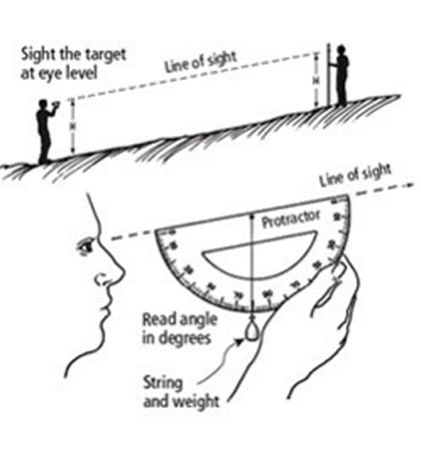
For homes sited along waterways or shorelines, follow all local ordinances regarding waterfront property. The U.S. Environmental Protection Agency WaterSense recommends that during verification, the verifier will use a laser level, clinometer, or other method to determine if slopes are greater than 25% or 14 degrees (i.e., 4:1 slope), then verify that slopes greater than 25% have vegetated plantings (e.g., groundcover, shrubs, tall grasses, etc.).
Source
Region
In locations prone to hurricanes, high winds, and coastal flooding, consider the following to reduce erosion at the site:
- Consider the need for mitigation of current and future erosion potential as part of site preparation, during construction, and at construction project completion, especially in locations prone to heavy rains.
- During construction, use erosion and sediment control practices, including mulch and erosion control blankets or bags, to reduce displacement of disturbed soils.
- For homes located along shorelines, waterways, or in watersheds, most municipalities have specific site requirements. Inquire about these during the planning phase. Construct according to local requirements.
- In windy climates, designers should consider the effects of long-term wind and water erosion upon a building over the course of its lifetime as well as the risk of mudslide. (FEMA 2011).4
Training
Right and Wrong Images
Source
Report by the FEMA Mitigation Assessment Team on damages due to Hurricane Irma which struck Florida in September 2017, and recommendations for construction for future disaster resistance and preparedness.
Source
Guide describing details that serve as a visual reference for each of the line items in the Water Management System Builder Checklist.
Source
A publication developed by the U.S. Forest Service for its employees and other federal agency staff describing erosion control methods.

Source
Guide describing tools for island and hurricane-prone communities on redevelopment and rehabilitation of homes to prepare for future natural disasters.
Source
Document discussing methods to bioengineer stabilization of shorelines using living and non-living plant materials in combination, known as the “Living Shorelines” concept.
Source
Source
Videos


Retrofit
Guidance for the measures described in this guide is applicable to both new and existing homes. Homes with established landscapes may require replacing turf and other plants to follow the guidance.
More Info
References and Resources
*For non-dated media, such as websites, the date listed is the date accessed.
Contributors to this Guide
The following authors and organizations contributed to the content in this Guide.
Sales
Efficient Landscape Design = Water Saving Landscape Design
Technical Description
Landscaping irrigation needs can be reduced or even eliminated by choosing native, drought-tolerant species that can survive on available rainfall and by installing non-plant ground covers like rock and bark. If there will be plants that require irrigation, they can be planted in clusters for efficient irrigation, while the remainder of the yard receives little or no irrigation.
Questions? Comments? Contact our webmaster.